You are at - Jotaro's Blog / Footsteps / Travel Tips-AhPek Biker / South Island New Zealand
JOTARO'S TRAVEL TIPS
NEW ZEALAND 2014 : CHRISTCHURCH, QUEENSTOWN, DUNEDIN & OTAGO CENTRAL RAIL TRAIL

Hope this will be helpful.

The very first thing one should do is to get a local New Zealand mobile phone SIM card. The pre-paid ones from Vodafone charges only NZD49-00 for 2GB of data, 120 mins of talk time (including to certain home countries), and 200 text messages. The deal is for 60 days.
I did find it odd though when making calls back home to Malaysia, I had only used something like 12 minutes of talk time and was barred from making any further calls home???
Useful Net Sites:
For Travel Spots:

- New Zealand Travel Guide- Christchurch Travel Guide - Wikitravel
- Queenstown New Zealand Travel Guide
- Dunedin Travel Guide
- Otago Central Rail Trail (For Cycling)
- The Rough Guide to New Zealand (eBook)
For Transportation & Accommodations:
- Jucy Rentals (Car & Vehicle Rental)
- New Zealand B&B (Bed & Breakfast) (For Accomodations)
- New Zealand Intercity Buses (for cheap lodging in Tokyo)
- KiwiRail Scenic Journeys (Travelling by train in NZ)
- Taieri Gorge Railway (A very scenic rail journey from Middlemarch/Pukerangi to Dunedin).
- Air Asia (for Air Travel)
- Virgin Australia (for Air Travel)
- Air New Zealand (for Air Travel)
- for air travel, kindly check the baggage and sports equipment allowance for each airline respectively as they may differ.
- Booking.com (Hotel bookings - this site is good as no deposits required, pay at counter)
- Agoda.com (Hotel bookings)
- Tripadvisor (Hotel users' reviews)
Useful Apps For Hand-phones:
- AA Tourism Mobile App (for iPHone)
- NZ Herald App Recommendations (Multiple apps for Android & iPhone)
- m.metservice.com (check on latest weather in towns and rural areas)
- City Maps 2Go (offline maps for iPhone, $2.99)
- City Maps 2Go (offline maps for Android, free)
- My Parx App (an app for parks maps, facilities, etc.)
- NZ Herald App Recommendations (Multiple apps for Android & iPhone)
- m.metservice.com (check on latest weather in towns and rural areas)
- City Maps 2Go (offline maps for iPhone, $2.99)
- City Maps 2Go (offline maps for Android, free)
- My Parx App (an app for parks maps, facilities, etc.)
- Easy Taxi (Booking taxies for Android, free)
SHOPPING & EATING TIPS

-Cheap souvenirs can be obtained in Queenstown from a shop at Shotover Street operated by a Chinese.
- Cheap souvenirs, skin care cream, etc. can be obtained in Te Anau from a shop at the Town Centre junction operated by a Chinese Lady.
- Good Manuka Honey, Thyme Honey, Clover Honey can be obtained from the Hunny Shop at Garston. Link : Garston Stable Hunny Shop; Telephone +6403-248 8990. E-mail : legendsdownunder@yahoo.com.
- Fergburger in Queenstown sell good, big and well-priced burgers from NZD11-00.
- Eating out in New Zealand can be expensive, a better way is to cook whenever the accommodations have cooking facilities.
> For buying Asian food try Kosco.
> For others try PAK'nSAVE.
- For further savings and to simplify cooking, bring along cooking pastes from your home country.

Useful Maps
(click on maps for enlarged view)

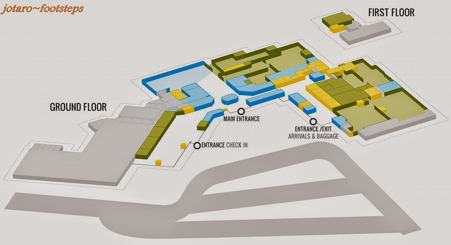
Christchurch Airport Terminal Building Ground Arrival Lounge Plan

Christchurch Airport Terminal Building First Floor Departure Lounge Plan
Queenstown Airport Terminal Building Plan

Christchurch Airport has an Air Lounge for passengers who has an early morning flight to catch. It is opened from 8:30pm to 5:00am and the charges are NZD5-00 pax or NZD20-00 per family. This saves passengers a fair bit of money and time by avoiding having to stay overnight at a city hotel.

Passenger can relax/sleep on the limited bean bags provided. Blankets are also provided and one can sleep on the chairs or floors. For those wanting to do some serious work, counters with bar stools are provide. Ample power points are provided too!
The Air Lounge has a limited capacity of 48 persons, so do go there fast.
A TV provides some entertainment while another screen provides the departure flight schedule.

For those intending to fly via Sydney, above is the Terminal Layout Plan for Kingsford Smith Airport.

Left Luggage charges for Kingsford Smith Airport. Note: folding bicycles charges are the same for prams.

Christchurch City Cathedral Square North Street Map.

Christchurch Hagley Park & Botanical Gardens Map.

Christchurch Antarctic Centre Map

Queenstown City Centre Map


Queenstown Cycling/Waliking
Trails Map

Queenstown Cycling Trails Map

Lake Wakatipu Area Map (Note: the dotted line shows the route of the steamship Earnslaw.


Dunedin Urban Map

Dunedin Central City Map

Dunedin City Centre Map


Taieri Gorge Railway Route Map


The Road from Te Anau to Milford Sound Map.

Milford Sound Cruise Time-table.
The following maps are applicable for cycling along the Otago Central Rail Trail in New Zealand.
For an interactive topography map of the rail trail click here - NZ Topo Map.
For an interactive topography map of the rail trail click here - NZ Topo Map.
A SPECIAL TIP FOR CYCLISTS:
Buses normally charge extra for bicycles. But our Bromptons folded so compactly and when in it's cover bag it look just like luggage, so we did not have to pay the extra as they were treated as normal luggage.

Clyde to Alexandra The Millenium 150th Anniversary Trail Map.
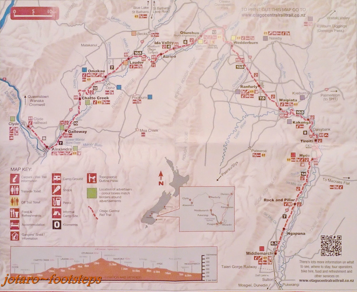
Otago Central Rail Trail Cycling Map.

Otago Central Rail Trail Distance and Elevation Plan.
The following are street maps of some towns along the Otago Central Rail Trail. Posted here to aid users for the rail trail in case they are looking for food and accommodations in these towns.
 Area Map of Alexandra & Clyde.
The Otago Central Rail Trail starts from Clyde. On the other side of the Clutha River is the 150th Anniversary Walk on which we used to cycle from Clyde to Alexandra.
 Clyde Street Map.
 Alexandra Street Map.
 Clyde to Alexandra to Galloway to Chatto Creek to Omakau - Otago Central Rail Trail Map.
 Alexandra to Galloway to Chatto Creek to Omakau to Lauder - Otago Central Rail Trail Map.
 Oturehua to Wedderburn to Ranfurly - Otago Central Rail Trail Map.
 Oturehua to Wedderburn to Ranfurly to Kokonga to Hyde - Otago Central Rail Trail Map.
 Ranfurly Street Map.
 Ranfurly to Waipiata to Kokonga to Daisybank to Tiroity to Hyde - Otago Central Rail Trail Map.
 Waipiata District Map.
 Kokonga to Daisybank to Tiroity to Hyde to Rock & Pillar - Otago Central Rail Trail Map.
 Middlemarch Map.
This is where the Otago Central Rail Trail ends.
The Otago Central Rail Trail starts from Clyde. On the other side of the Clutha River is the 150th Anniversary Walk on which we used to cycle from Clyde to Alexandra.
This is where the Otago Central Rail Trail ends.
You may also like :
 |
 |
 |
 |
 |
 |
 |
 |
 |
 |
 |
| Cambodia : Phnom Penh Museums - Day 1 National Museum : December 2012 A surprisingly educational visit to the National Museum of Cambodia. |
 |
 |
 |
| Be captivated by the water-puppets and awed by the beauty of Ha Long Bay. |


If you like this, view my other blogs at Jotaro's Blog
(comments most welcomed below. if you like this pls share via facebook or twitter)
No comments:
Post a Comment